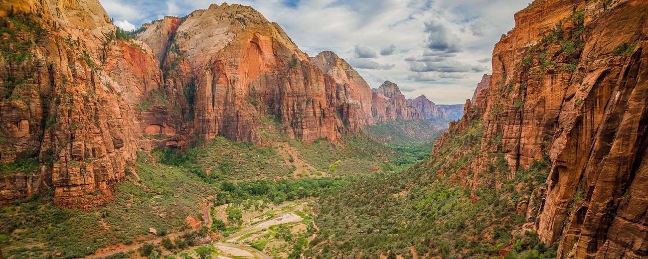
Zion National Park enjoys two areas for recreation. Take a minute to read through the information below to gain a better understanding of the layout of the park and the many things to do within those different areas.
- Loading
Your request has been processed, thank you!
We also have the following visitor guides in Utah. Click on any additional guides you would like to receive.


Utah - Life Elevated Statewide
Utah - Life Elevated




Emery County, Utah South Central Utah
Emery County, Utah




Flaming Gorge Country Northeastern Utah
Flaming Gorge Country


Bear Lake Northern Utah
Bear Lake





Davis County Northern Utah
Davis County


Uintah County - Vernal Northeastern Utah
Uintah County - Vernal





Heber Valley North Central Utah
Heber Valley


Zion National Park - North Rim Grand Canyon Southern Utah
Zion National Park - North Rim Grand Canyon




Moab Southeast Utah
Moab





Park City Summer North Central Utah
Park City Summer


San Juan County Southeast Utah
San Juan County


Palisade, Colorado Western
Palisade, Colorado


Capitol Reef Country Central Utah
Capitol Reef Country


Visit Moffat County Northwestern Colorado
Visit Moffat County





Park City Winter North Central Utah
Park City Winter


Ski Utah Utah
Ski Utah




Explore Utah Valley Utah
Explore Utah Valley





Visit Ogden - Northern Utah Ogden
Visit Ogden - Northern Utah




Cedar City & Brian Head Southern Utah
Cedar City & Brian Head


Logan - Cache Valley Northern Utah
Logan - Cache Valley


Box Elder County Northern Utah
Box Elder County





Richfield, Utah Central Utah
Richfield, Utah


Bryce Canyon Country Southern Utah
Bryce Canyon Country
We also have visitor guides available in states highlighted in blue below. Click on any state to see what's available.
- Alaska
- Arizona
- California
- Canada
- Colorado
- Hawaii
- Idaho
- Louisiana
- Michigan
- Montana
- Nevada
- New Mexico
- Ohio
- Oregon
- Texas
- Utah
- Washington
- Wyoming
Overview
 Zion is comprised of two areas. Zion Canyon in the southeast portion of the park (light brown area on map) holds the most spectacular scenery and is by far the most visited area of the park. A short paved road runs along the bottom of the canyon past scenic views and numerous trailheads.
The Kolob comprises the rest of the park. A short scenic drive off of I-15 brings you to some good overlooks and a few trails, but most of this area is comprised of remote backcountry more suited for backpacking trips.
Zion Canyon
A 6-1/2 mile long scenic drive runs along the Virgin River on the floor of Zion Canyon. Accessible by shuttle bus or bike, it is the premier drive in the park and provides sensational views of the canyon walls that tower 2000 feet overhead. Along the way are numerous hiking trails, picnic areas and the Zion Lodge.
 The main scenic drive is a spur road off the Zion-Mt. Carmel Scenic Byway (Hwy 9). Hwy 9 enters the park from the south through the town of Springdale and climbs east up and out of Zion Canyon in a wonderfully steep ascent on switchbacks and through long tunnels to the eastern edge of the park. (See Other Things to Know for special tunnel rules.) This 13 mile scenic drive takes you past some striking scenery, including Checkerboard Mesa.
You'll need a day to explore the Zion Canyon area, though more time spent will not go unrewarded. Early morning and late afternoon have the best light (and fewest people). You should definitely plan on taking a few of the many great hikes in this area.
Important: The Zion Canyon Scenic Drive is accessible by Shuttle Bus ONLY from early April through the end of October.
The Kolob
The backcountry of the Kolob lies to the north and west of Zion Canyon. Though it is quite attractive, it is a much less visited area of the park. It consists of the Kolob Canyon area and the Kolob high country. Select Hiking for details about hiking in this area.
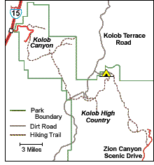 Kolob Canyon is located in the northwestern corner of the park just off I-15. Twisting Kolob Canyon Road climbs 1000 feet in just 5 miles to a pleasant picnic area and great lookout over the finger canyons of the Kolob. Along the way are some nice pull-offs and access to a few trails (described below). A visitor center is at the entrance.
The Kolob high country makes up the middle section of Zion. Kolob Terrace Road runs north from the town of Virgin through this area to Lava Point. At Lava Point is a great panorama taking in the Cedar Breaks area, the Pink Cliffs, the Zion Canyon Narrows and the towering monoliths of Zion Canyon.
Other Things to Know
Tunnel Restrictions
On Hwy 9 east of the main Zion Canyon Scenic Route is a long narrow tunnel through which RV's taller than 11' 4" or longer than 40 feet (or 50 feet with a trailer) need an escort. A $10 escort fee, good for two trips through over a 7-day period, can be purchased at either park entrance on Hwy 9. In summer, rangers are stationed at the tunnel to take you through from 8 to 8. At other times an escort must be arranged in advance at the east entrance to the park or at the visitor center (801-772-3256).
Parking Restrictions
RV's longer than 21 feet may not enter the Weeping Rock parking area nor park at the Temple of Sinawava parking lot. There is a special drop off area for passengers in such vehicles at the Temple of Sinawava. RV's can park in the park at the Zion Lodge parking lot. The Zion Lodge operates an open air shuttle bus from the lodge to the Temple of Sinawava for a small fee.
Pets
Pets that are leashed may be walked on the Pa'rus Trail. However, pets are not permitted on any other trails, on shuttles, in public buildings, or in the backcountry. Pets must be under physical control on a leash less than six feet at all times. The interior temperature of a vehicle can quickly warm to dangerous levels. Avoid leaving animals in vehicles.


